Ferry Logo

Ferry Logo

Wednesday 24 December 2014

Balmain East - are too many berthings barely enough, or are they just too many?

Plans for the new ferry terminal at Barangaroo include a big rise in ferry frequencies on the Darling Harbour (F4)Line. Week-day AM peak departures from Barangaroo will increase from two per hour to six per hour in 2016. Week-end peak departures will increase from three per hour to eight per hour.
 
The Barangaroo terminal can probably manage 7.5 minute headways for the Darling Harbour Line. But what are the implications for other Darling Harbour line stops, especially if all initiatives in the Sydney's Ferry Future plan are taken into account? Currently all services on the Darling Harbour Line also stop in both directions at Milsons Point, McMahons Point and Balmain East.  

The Ferry Future plan was released by the NSW Government in May 2013. A close reading shows a significant change to the role of Balmain East wharf, currently a quiet little place with two berthings per hour on week-days in the direction of Darling Harbour and two per hour in the direction of Circular Quay. The Ferry Future vision is that it becomes an interchange for three lines - Parramatta, Woolwich and Darling Harbour.

The consequences of this, in combination with the threefold increase planned in Darling Harbour services, are enormous. As shown in the table below, Balmain East departures in the AM peak periods will increase sevenfold - from four per hour to 28 per hour. That's one ferry departure every two minutes!


Darling Harbour Line departures in 2016 based on the assumption that the Darling Line will continue to be an all stops service.  
Increased frequencies are normally welcomed by customers, but there are operational considerations peculiar to ferries which mean that 28 berthings an hour will be plain annoying.  It usually takes a minimum of two minutes for each vessel to berth, including tying and untying lines, planking the gangway and time for passenger loading.

Even with the dual berthing planned in the upgraded BaImain East Wharf, berthing conflicts in the timetable are inevitable, forcing vessels to be held off the wharf waiting for the previous ferry to depart.

There is also the impact of additional wash on the sea wall at Balmain East from the increase in vessel movements.

It is time for some re-thinking to be done on the Sydney Ferry Future plan. An increase in service frequency is a good thing, but there is a point where the network reaches overload.  Departures every two minutes is neither justified by demand nor operationally sustainable.

Monday 15 December 2014

The New Barangaroo Ferry Terminal - First Impressions

Source: Barangaroo Delivery Authority 
Few infrastructure projects will be more critical to the Sydney Ferry network in the next 30 years than the new terminal at Barangaroo. The importance of getting it right cannot be overstated.

The terminal will replace the current King Street wharf located 200 metres south. The NSW Government's commitment to build the terminal allows some rethinking about the best way to organise the Sydney Ferry network, especially for servicing locations west of Sydney. Barangaroo, in combination with the Wynyard Walk development, provides an ideal entry point for commuters from this side of the city.

Its desirability will be further enhanced if the planned Sydney Rapid Transit line includes a stop at Barangaroo. This could provide a convenient connection between the ferry and SRT networks.  

Design details for the new terminal were released last week, accompanied by a 323 page Environmental Impact Statement and an invitation for feedback from the public. http://majorprojects.planning.nsw.gov.au/index.pl?action=view_job&job_id=6727

Initially two double faced pontoons will be constructed (four wharf faces) with the option of building a third at a later date.

A ferry terminal should allow vessels to load and unload passengers quickly and safely, enabling passengers to move effortlessly from one line to another or transfer to another mode of transport. To accomplish these objectives, there are many details to be sorted out before the design is finalised:
  • which lines will connect at the terminal?
  • how frequently will vessels stop (what will the timetable be, now and in the long term)
  • what will be the peak number of disembarkations for each arrival? What will be the peak numbers embarking?
  • how much time will transferring passengers have to move between vessels and how will this happen? 
These are just some of the details to be resolved.

If you are looking for answers to these questions, the EIS is not very illuminating. Where demand forecasts are provided, the reader is left wondering if they are credible.

Role of Barangaroo in the Ferry Network

The EIS remains true to the Sydney Ferry Futures strategy of May 2013. This means initial plans are only for two lines (Parramatta River and Darling Harbour) to stop at Barangaroo. But Sydney's development plans are moving quickly, so why not consider a line which connects Barangaroo with the Bays Precinct renewal? And why not terminate the Cockatoo Island line at Barangaroo instead of Circular Quay? This would make Barangaroo a real hub to take pressure off the congested Circular Quay.

With at least four wharf faces available at the new terminal, such an expansion could easily be accommodated. 

Demand Assumptions

Sydney has a history of transport projects with ambitious demand forecasts. This one is no exception.  Some of the forecasts include:
  • Week-day AM peak arrivals at Barangaroo to increase from the current 650 (King Street) to 3,000 in 2016. The 650 includes 150 on Darling Harbour services and 500 from the Parramatta River. Even if all the 550 River passengers who currently go to Circular Quay in the peaks suddenly elect to go to Barangaroo instead (note there is no plan to cease Circular Quay arrivals from the River), where will the other 2,000 come from? The ferry mode share of growth locations like Wentworth Point and Meadowbank has always been low and they will not contribute more than a trickle of extra passengers, even if a new wharf is built at Rhodes.
  • Ferry journeys are "estimated to grow at up to 8% per year through to 2026". Compounded over 12 years, that means ferry patronage is forecast to increase to 42 million in 2025-26, a rise of 160%, yet overall growth in all journeys to the CBD is only forecast to rise 23% in 20 years!
There are also some surprising projections for capacity growth. Week-end services are projected to increase from three to eight per hour on the Darling Harbour line and from two to six on the Parramatta River. The flow on congestion elsewhere in the network caused by such a change is hard to imagine.  Balmain East, which the Ferry Futures report nominates as an interchange for the River, Darling Harbour and Cockatoo Island lines, will resemble something like Central Station, with a conga line of boats waiting to berth.

Passenger Ingress and Egress

A blind spot in recent Sydney wharf infrastructure projects is crowd management and passenger ingress and egress. On a busy Sunday, let alone a big event, a First Fleet ferry can unload close to 400 passengers at Darling Harbour, while another 400 wait to board. 


The pontoons proposed for Barangaroo are wider than those at Circular Quay - 23 metres compared to about 18 metres at the Quay. This is welcome, but the design problems of Number 2, 4 and 5 wharves at Circular Quay are repeated in the Barangaroo plans. Despite the pontoons being wider, the waiting areas are not large enough.

The combined waiting area for the two wharf faces is about 200 square metres. This includes seating, which effectively reduces the available space. On busy days, it is quite conceivable that over 600 passengers will be waiting to board a First Fleet ferry on the north face of the pontoon and a RiverCat on the south face. It is simply unsafe, expecially with multiple strollers and some passengers in wheelchairs, to cram three people per square metre into the waiting area. The US Transportation Research Board manual on Transit Capacity and Quality of Service advises that where densities are greater than 1.5 persons per square metre in a queuing area, "long term waiting is discomforting"(1).

Many Sydney residents have experienced discomfort and fear of injury while waiting on an overcrowded pontoon at Circular Quay. This should not be allowed to happen at Barangaroo. 

Building the new terminal is also an opportunity to modernise gangway technology to speed up passenger loading and unloading. Whether this will be done at Barangaroo is not clear.  The concept design drawings show mobile ramps which look worryingly similar to the current set up. It should not be impossible to design a better vessel/ pontoon interface which allows 400 passengers to quickly disembark and 400 others to quickly board.

Summary

The Barangaroo terminal can set the agenda for the future of Sydney's urban transit ferry network. Currently released documents disappoint on a number of fronts:
  • lack of clarity about its relationship to the overall ferry network, with no acknowledgement of a possible role in serving the Bays Precinct or the existing Cockatoo Island line.
  • overly optimistic demand forecasts for the Parramatta River
  • insufficient attention to crowd management, which raises concerns about passenger safety
  • no strategy for improving the efficiency of passenger loading/ unloading.
But all is not lost, as the community consultation period has just started. Let's hope that constructive feedback will be acted on.  

Footnote
(1) Transportation Research Board: Transit Capacity and Quality of Service Manual - 2nd Edition. Part 7 Stop, Station and Terminal Capacity  http://www.trb.org/Main/Blurbs/153590.aspx 

Thursday 4 December 2014

More about the new ferry fleet design for Sydney

 
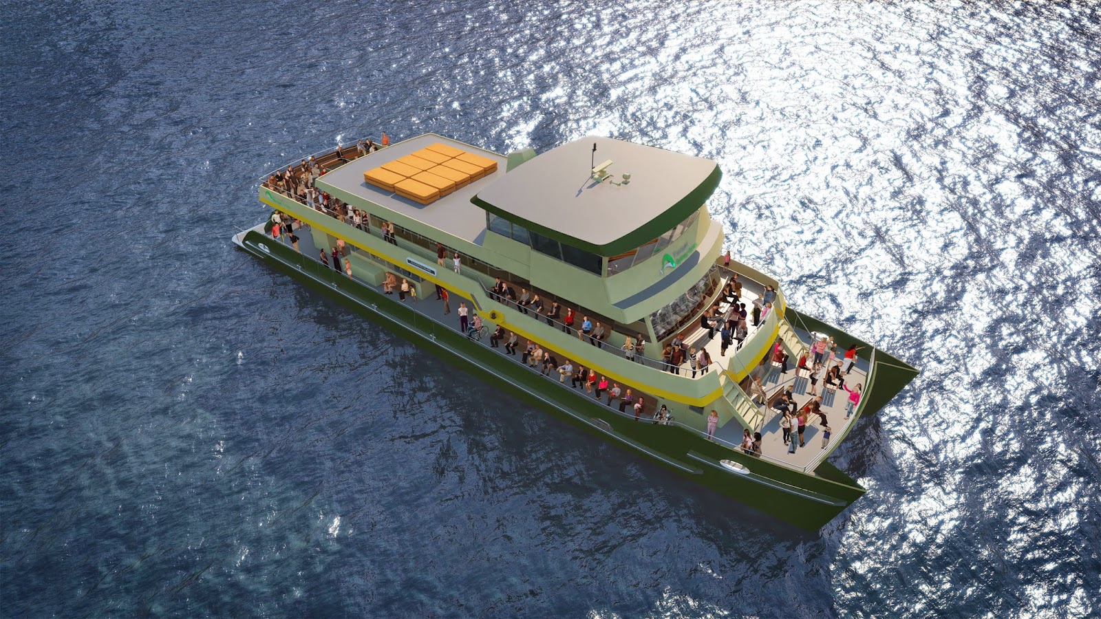
There's a lot to like about the new ferry design. Perhaps it's the seductive Transport for NSW video. The author has now watched it far too many times, but then this is necessary for professional reasons to take in all the detail.

Sure, a double ended catamaran might be more practical. This would remove the need for ferries to make those dangerous reversing manoeuvres at Circular Quay or Barangaroo and reduce transit time.

And a big capacity (400 passenger) vessel is expensive to run and probably locks the ferries into a 30 minute interval network in the Inner Harbour. Smaller vessels operating at lower cost and higher frequency could create a better quality public transport system with greater ridership.

The heart, however, says the new boat is beautiful.

The original Alan Payne designed First Fleet Ferries are cute and stubby, but the lines of the new design are somehow more graceful and better proportioned. This may simply be because the original design in 1982 was cruelly shortened by the Urban Transit Authority in a failed attempt to save on crewing levels. Perhaps the upper deck of the original design had a similar spacious open area for passengers to enjoy views of Sydney Harbour.

Not sure, but whatever happened in history, the new design by the Sydney naval architect team One2Three seems to have corrected the wrongs committed more than 30 years ago.

The new design has much to admire. The seating arrangements look relaxed and spacious. As one would expect, the old First Fleeter seating, reminiscent of a Commonwealth Employment Service waiting room circa 1983, is replaced by something more comfortable, including some (but not too many) seats with tables.  Crews like the practicality of vinyl, but passengers will appreciate the comfort of new seats.


Boarding will be faster as the entry inside on the main deck is much wider and more open than the old ferry. It is hard to see a log jam of strollers posing a problem here.

Bike racks on the main deck will be a boon for cyclists. 

With a maximum operating speed of 24 knots, it has the flexibility to handle the open water runs to Rose Bay and Watsons Bay and could pick up a bit of time on the Cockatoo Island run once it heads west of Ballast Point. No doubt it has a low wash design, so recreational vessels moored in the inner harbour will not be subject to the tsunami's sometimes inflicted by the old First Fleeters.

Best of all, the open seating on the upper deck looks fantastic. There will be a stampede for the seats in front of the wheelhouse.


One word of caution: gangways. Followers of this blog will know it is an obsession of the author. Please let there be more advanced gangway technology on the new vessels to speed up embarkation and disembarkation. The animation in the video shows gangways ominously similar to the current design.

Apart from this reservation, congratulations to the One2Three team and to Minister Gladys Berejiklian for extending the life of one of Sydney's great icons.     

Wednesday 3 December 2014

Achieving more with less in an urban ferry network

It can be hard to get your head around why a properly structured urban transit ferry network is more efficient. It's a bit like a well organised wardrobe. Neatly arranged socks and pressed shirts save space and it's easy to find whatever you want.

An integrated regular interval timetable (IRIT) is the same. With the same number of boats, a lot more can be achieved for passengers. Ridership goes up and net costs come down. It also allows space to be used more efficiently in a sometimes crowded maritime environment.  
 
The essential elements of such a network are:
  • all lines operate a strict clockface timetable. For example, departures from the local wharf, in the direction of the city, might always be 13 and 43 minutes past the hour. There may be additional departures in the peaks, but the underlying off peak pattern is retained through the peak period also.
  • stopping patterns on inbound and outbound trips are symmetrical. This means inbound and outbound trips on the same line have the same duration. 
  • connections between lines are integrated at network nodes. Optimally, vessels arrive at nodes three or four minutes before the hour and half hour and then depart three or four minutes after the hour and half hour. This means passengers can transfer between lines without inconvenience.
The benefit for passengers is obvious. Networks designed this way dramatically increase the number of convenient origin-destination (OD) pair connections. 

That some passengers need to make transfers between lines to complete a journey may be seen as a disadvantage, but as transfers are timed, and the connection holds good for all departures, it is not a major inconvenience.  


There are economic benefits in moving to an integrated regular interval timetable. This is because the significant jump in OD pair connections causes ridership to grow at a much faster rate than the operational costs.

The diagram below shows what an integrated regular interval timetable ferry network could look like in Sydney. Circular Quay is the hub for lines east of the city; Barangaroo is the hub for western lines. They are connected by the Darling Harbour line.


Features of the network are:
  • new stops at Rhodes and Elizabeth Bay
  • a new line for the Bays Precinct, with stops at Jacksons Landing, Rozelle and Glebe Point
  • span of service for Watsons Bay extended to include AM and PM peaks (30 minute headways)
  • timed transfers at Barangaroo and Circular Quay on the hour and half hour.
  • Balmain East is a partial node, which means passengers on the Cockatoo Island Line can transfer here for departures to and from Circular Quay, or continue on to Barangaroo.
  • timed transfers at Cockatoo Island, so passengers on the Cockatoo Island Line can connect conveniently with Parramatta River services.    
The network takes advantage of improved access to the Sydney CBD from its western edge as a result of the Wynyard Walk and Barangaroo developments. It also neatly links the proposed Bays Precinct renewal to the entire ferry network.

Overall, convenient origin-destination pair connections increase more than fourfold, from 96 to 404.

One might expect that such an improvement in customer outcomes would be more costly, with additional vessels and increased taxpayer subsidy. No, it reduces net costs to taxpayers.

The following table compares the existing Sydney Ferry network with the integrated regular interval timetable network proposed in this post:

Current ferry operator payments and revenue sourced from Auditor General's Report Vol 7, November 2014  


It is hard to predict the ridership impact of a fourfold increase in convenient OD pair connections - it is conservatively estimated here to be 40%. While there is an 12% increase in service hours, the extra costs in operator payments are more than offset by the extra revenue from ridership growth. 

The peak fleet requirements are unchanged because of the efficiencies inherent in an IRIT network. Operating costs per service hour are also reduced as labour costs will be less.    

The economic benefits don't end with reduced subsidies to the ferry operator. An IRIT network also means it is easier to share waterways with other users, such as cruise ships.

Sydneysiders are familiar with the impact of a large cruise ship berthing in Sydney Cove. It is disruptive for all vessel movements in the harbour.

If all lines in the ferry network are scheduled to arrive and depart Circular Quay around the hour and half hour, there are two 10 minute slots free every hour when no ferries are entering or departing Sydney Cove. This means a crowded maritime space can be safely shared for the economic benefit of Sydney.

For those who like details, the following table provides more information on what each line could look like in a Sydney ferry network based on IRIT principles.


Friday 28 November 2014

New Ferries for Sydney's Inner Harbour in 2016

Image sourced from Sydney Morning Herald
It is fitting that the design of new ferries for Sydney's inner harbour was announced today. The plucky First Fleet Class, designed by Australia's finest naval architect, Alan Payne, entered service on this day 30 years ago. 

The timing would not have been a coincidence.

What's more, the new design is very much a tribute to the classical boxy lines of our most iconic ferry, including the working boat style inverted windscreen, seating around the full circumference of the main deck (and upper deck in the new design).  And of course the green and cream livery.

The First Fleet ferry is to Sydney what the red double decker Routemaster bus is to London. It is part of the branding of Sydney. Minister Gladys Berejiklian clearly understands this and the economic benefits it brings to New South Wales(1).

Emotions aside, there are also practical considerations.

According to the Sydney Morning Herald, six vessels will be built, with the first to go in service within two years. http://www.smh.com.au/nsw/new-sydney-ferries-set-to-sail-from-2016-20141127-11v1yz.html The comment in the Herald that they will replace the First Fleeters is surprising as the original plan was to replace the older Lady Class boats and the troublesome SuperCats.   

One would hope the new design will be the standard for the inner harbour network, to avoid the inefficient hotch potch of vessel classes that currently operate and which drew sharp criticism from Brett Walker's commission of inquiry in 2007.

So if this is to be the new standard for inner harbour vessels, is the design the right one?

The detailed design has not yet been released, but we do know its maximum operating speed is faster than the First Fleeters. This is a good thing as it will cope with longer trips in open water to destinations like Rose Bay and Watsons Bay.  

It is also a large boat with a passenger capacity of 400. Under Uniform Sea Law, that could mean a minimum crew requirement of four, up from the three person crews in the current First Fleet vessels.

This rings some alarm bells. Brisbane ferries have operated a small boat/ high frequency strategy with great success.
Smaller ferries have reduced crewing requirements, are cheaper to run and the engineering requirements for wharf infrastructure are less demanding.

The Brisbane experience shows that smaller ferries operating at higher frequencies attract higher patronage and make a more economically efficient network.      

Issues of detail will emerge when the full plans are released. The image published in the Sydney Morning Herald shows two gangway gates, which is positive, but not the more advanced "fold down" gangways used on Brisbane Ferries where pontoons and vessel freeboards are equalised.  

One of the most serious shortcomings in the current network is the inefficient passenger loading technology.  Is there a plan to speed up passenger embarkation on Sydney Ferries? This has implications for the design of both vessels and wharves.


Note

(1) Unfortunately, the Independent Pricing and Regulatory Tribunal (IPART) does not seem to have the same level of understanding and assesses the external benefit of ferries to be close to zero.


Friday 14 November 2014

The Integration of Barangaroo and Bays Precinct in Sydney's Ferry Network


Last week's post touched on how the ferry network could be extended to the Bays Precinct, an area west of the Sydney CBD, including Rozelle Bay and Glebe Island.

This week's post is about integrating the Bays Precinct and the new Barangaroo ferry terminal into the overall ferry network.

The Issue

A big improvement will be made to Sydney's CBD when the Wynyard Walk project completes in 2016. It will significantly enhance access to the centre of the city from its western edge, including the new ferry terminal at Barangaroo South.

Most people approaching the city from the west will find it easier to walk to their place of work from Barangaroo South, rather than Circular Quay. The current painfully slow navigation of multiple road crossings and pedestrian lights up Erskine Street will be replaced by a pleasant unimpeded six minute stroll to George Street in the heart of the city.

It will also provide easy access to Wynyard Station, a bigger interchange than Circular Quay station with more train lines.   

The ferry network must adapt to these new circumstances.

Accompanying this change is the urban renewal proposed for the Bays Precinct. Although decisions have not yet been taken, high density residential development is probable at Glebe Island. Rapid growth is already happening on the site of the old Harold Park at Glebe. Glebe Point residents can attest to the problems of commuting to the CBD by bus (some find it quicker to walk). Adding to the conga line of buses crossing ANZAC Bridge does not seem like a workable solution for future Glebe Island residents either.

A new ferry line from Glebe Point to Barangaroo, with stops at Glebe Island and Jacksons Landing at the Johnstons Bay side of Pyrmont would be a sound approach, complemented by an additional pedestrian bridge between Pyrmont and Barangaroo South.

Ferry commuters travelling from the western side of the CBD will also expect to have access to Barangaroo South. Currently those travelling from Woolwich, Greenwich, Birchgrove and Thames Street Balmain have no choice but to travel to Circular Quay.

Let's not forget that the CBD is just one of many destinations that people may have.

Public transport networks work best when lines are integrated and passengers find it easy to navigate their way to wherever they need to go, which is not necessarily just the CBD. That's why the best networks are multi-destinational.  

If you live at Glebe Point, Glebe Island or Jacksons Landing, you may want to go Milsons Point, Manly, Taronga Zoo or somewhere up the Parramatta River. The network should maximise the connection between origin-destination pairs, with convenient timed transfers between lines.

The Solution

Making Barangaroo and the Bays Precinct part of an Integrated Regular Interval ferry network offers the most efficient solution with the best outcomes for passengers:
  • Regular Interval means strict adherence to clockface headways in the timetable, all day/ seven days a week.
  • Integrated means co-ordinating arrivals and departures at network nodes to provide convenient timed transfers. 
    A possible new design for the Sydney Ferry network
    
The solution proposed here is to make the Glebe Point line an extension of the Darling Harbour (F4) line. It also extends in the other direction to Taronga Zoo via Circular Quay, avoiding the need for zoo goers to change at Circular Quay. Neutral Bay through lines with Double Bay and convenient timed transfers are scheduled at Circular Quay between the Manly, Darling Harbour, Mosman, Neutral Bay, Double Bay and Taronga Zoo lines. Convenient timed transfers are also scheduled between the Parramatta River and Watsons Bay lines. 

A new stop is also proposed at Elizabeth Bay on the Double Bay line.

The Glebe Point line would operate at 30 minute intervals all day, consistent with the existing Darling Harbour line. Frequency in the peaks could be increased to 15 minute intervals if demand was sufficient.

As an example of how ferries could assist the mobility of, say, residents of Glebe Island, here is a table showing examples of ferry journey times from this location to other destinations in the ferry network.   

Journey times from Glebe Island to sample of destinations in proposed new ferry network.
 The Benefits

Under the current ferry timetable, just 96 origin-destination pairs can be connected conveniently all day, seven days a week. That’s 16% of the total possible OD pairs. Because of the integration inherent in this proposal, convenient OD pair connections increase to 395, a four fold increase.

The other good news is that, while service hours will increase by 11% (funding for ferry services is mainly based on the time vessels operate timetabled services), the increase in farebox revenue will exceed the additional operating costs. This is because the improved usability of the network will drive significant patronage growth, especially in off peak periods.

Hard to believe, but a well designed ferry network providing quality public transport for the Bays Precinct can lead to a reduction in Government subsidies for Sydney Ferries.  

Friday 7 November 2014

A Solution to the Pyrmont - Barangaroo Access Problem

Source: Barangaroo Delivery Authority
The Barangaroo development on the western side of Sydney's CBD is progressing at a pace. Observers have correctly pointed out that better access is needed between Pyrmont and Barangaroo, especially as the existing pedestrian access at Pyrmont Bridge is already close to capacity.

As often happens, various "creative" ideas are thrown up as possible solutions. The Sydney Business Chamber has proposed a cable car to connect the two precincts. Maybe this is a joke, but then Sydney did get a monorail in 1988 which lasted 25 years before everyone realised that was a joke too.

The sensible option would be to build another pedestrian bridge with a dedicated cycling lane. The area occupied by the current Sydney Ferries wharf at Darling Harbour will be vacated in 2016 when a new wharf is built 200 metres north at Barangaroo South. The bridge could connect from the old ferry wharf to Pyrmont Wharf 7, adjacent to the Sydney Heritage Fleet.

This would provide easy access for pedestrians from Pyrmont to connect with both Barangaroo South and the Wynyard Walk.


From a ferry network perspective, this would remove the need to have a stop at Pyrmont Bay. Instead, a new line could be added from Barangaroo to Glebe Point, with intermediate stops at Jacksons Landing and Glebe Island. The Glebe Island stop would be subject to demand arising from whatever development is made as part of the Bays Precinct renewal program.

Continuing the line further to Annandale is also possible, as well as an additional stop near Jones Bay at the northern end of Pyrmont.

The distance by water from Glebe Island to Barangaroo is not great - only 2.5 km - but would be painfully slow if current 4 knot speed restrictions continue in Rozelle Bay. A little flexibility is needed from Roads and Maritime Services to increase this to 8 knots. This would provide competitive transit times to Barangaroo for passengers currently poorly served by public transport:
  • 8 minutes from Jacksons Landing
  • 11 minutes from Glebe Island
  • 15 minutes from Glebe Point.
Another benefit is that the existing Circular Quay - Darling Harbour line would have a more manageable cycle time of 60 minutes if it did not make the diversion to Pyrmont Bay, as it currently does.  


Thursday 30 October 2014

The Story of the First Fleet Ferries


Transport anniversaries have been coming thick and fast lately. The Gladesville Bridge turned 50 on 2 October and last week Japan celebrated 50 years of high speed trains.

Another milestone will be reached next month. The first of nine First Fleet ferries went into service on 28 November 1984. All nine continue to provide reliable service across Sydney's Inner Harbour.

The story of the First Fleet Ferries should be better known. We all know how the dead hand of bureaucratic incompetence stifled the creative genius of Jorn Utzon, but few know that a similar story lies behind the most iconic class of Sydney Ferries.

Funding for the new fleet was a gift from the Federal Government to the people of New South Wales as part of Australia's Bicentennial celebrations. After a tender process, Australia's finest naval architect, Alan Payne, was selected to design the boats.

The skill and accomplishments of Alan Payne are little appreciated outside the maritime community. He fails to rate a mention in the Australian Dictionary of Biography, yet his achievements are astonishing.

After a string of successes in designing Sydney to Hobart yachts, he was engaged by Sir Frank Packer to design Gretel, the first Australian challenger for the America's Cup in 1962. Gretel proved to be faster than the American defender Weatherly and some argue it would have won the series, but for erratic interventions by Sir Frank in crew management.

Payne also designed two other Americas Cup challengers, Gretel II and Advance and was inducted into the Americas Cup Hall of Fame posthumously in 2005. The better known Ben Lexcen was inducted in the following year.

When Payne was engaged to design a catamaran ferry for Sydney, he undertook the project with his customary passion, attention to detail and a classical design aesthetic.  He worked with Sydney boat designer Bill Bollard to refine the design. Bollard, who still lives on the Central Coast, says Payne's eye for hull lines was exceptional. He was also fastidious about meeting functional and passenger requirements. This led to the novel feature of twin rudders on each hull to provide superb manoeuvrability in Sydney Harbour's tight coves. He also ensured all passengers had unimpeded views out of the vessel, a feature sadly not continued in more recent ferry designs.

Not satisfied with tank testing, Payne and Bollard built two 20 foot prototypes for testing at Brooklyn and on the Lane Cove River. Payne's famous EH Holden, purchased after the Americas Cup Challenge in 1962, is seen in the picture below launching one of the prototypes in the Lane Cove River.
Photograph by Bill Bollard 
Following testing, Payne decided that a semi-asymmetrical  round bilge hull shape was the best design.

The final design was close to perfection, creating minimal wash.

This is where bureaucracy intervened. At its original length of 30 metres, wash patterns were minimised, but a vessel of this length was required by law to carry three crew. The Urban Transit Authority insisted that it be shortened, much to Payne's distress, to keep crewing levels down to two. The plans were changed and production commenced at Carringtons, Newcastle. 

In the meantime, agitation by Sydney Ferry staff led to crew levels being set at three anyway, so neither the labour cost savings nor Alan Payne's perfect, low wash design were realised.

The first ferry in service was the Sirius, followed soon after by the Supply. The early First Fleeters have more outside seating on the Upper Deck, which is generally appreciated by passengers in Sydney's mild climate.

Designing a ferry fleet, fit for purpose on Sydney's iconic harbour is no easy task. But for the interference of the Urban Transit Authority, Payne came close to designing the perfect ferry. Had he designed it today, he may also have allowed for better accommodation of 21st century strollers and more advanced gangways, but it remains a firm favourite of crews and the public.

Not every naval architect has the courage to go beyond the brief set for them by the client, nor the imagination or persistence to design something of genuine quality which accommodates the thousand and one little details that need to be considered. Alan Payne was such a person.     

As for the bureaucratic interventions in the early 1980's, well of course it would not happen today - would it?


Thursday 16 October 2014

What the Sydney Opera House and a Well Designed Ferry Network Have in Common: Patterns

Source: Sydney Morning Herald
Patterns are intrinsic to many scientific and engineering disciplines. Sophisticated and complex organisms and structures are built from simple interlocking patterns. The construction of the Sydney Opera House famously appeared to be impossible until its architect Jorn Utzon realised that all the shells of the building could be formed from the same basic shape, a 75 metre diameter sphere.

Patterns are also fundamental to the design of effective transport networks. A pattern is necessary to make the timetable legible for passengers, to use resources efficiently and to link lines in a way that make connections convenient.  

In transport, patterns are measured by time not distance.

Even if the network comprises a single line, passengers expect departures by the ferry (or train or bus) to be at regular intervals - say once every 30 minutes. This can only happen if the time required by the ferry to complete the outbound and inbound leg is a whole integer multiple of the service interval. The less frequent the departures, the more challenging this requirement becomes.  

The simplified network below is a 60' minute round trip with four intermediate stops at B, C, D and E and 30 minute headways. Vessels depart the starting point (A) two minutes past the hour and half hour and also depart from the end of the line (F) two minutes past the hour and half hour. As stop C is positioned 15 minutes from both the starting point (A) and the end of the line (F), inbound and outbound vessels always cross at C.


Two important observations can be made about this simple network:

  • A,C and F are nodes which are potential interchange points with buses or trains, because vessels travelling in both directions converge at these points at the same time. A single bus could connect at C with both the inbound and outbound vessel.

  • If a regular interval is maintained all day, and the vessels are punctual, they will never cross at B, D or E. This means these terminals do not need to be dual berthing, unlike C where the vessels cross all the time.

Realistically, most networks have several lines and they need to connect with each other. This is when patterns become really important.

In the following slightly more complex 30' interval network, four lines connect at a hub, "B". All routes "through line", so passengers travelling from A to C (or from D to E) do not have to transfer at the hub. Although the length of the lines vary, they all conform with the rule that each cycle time is a whole integer multiple of the service interval.


Two lines do not have intermediate nodes (B-C and B-E). Line B-D has one intermediate node and the other has three intermediate nodes.

This network has the potential for linkages with bus lines with timed connections at the nodes. Suddenly, from a very basic underlying pattern, following a very simple mathematical rule, it is possible to create a comprehensive, multi-destination transit network:


Another feature of an integrated regular interval timetable, like this one, is that the pattern leads to other surprising benefits:

  • all vessels arrive at the hub at the same time, two or three minutes before the hour and half hour, and all depart two or three minutes after the hour and half hour. This makes rostering much more efficient, because crib breaks can be scheduled in neat, modular blocks.
  • as the same pattern of vessel movements is repeated throughout the day, it is easier for ferry masters to develop a regular tempo or cadence. Potential safety risks are more predictable and punctuality is easier to manage.  
  • it is not difficult to add capacity for special events or to meet peak demand if the extra departures are scheduled at half the interval (eg 15 minute interval instead of 30). This does not disturb the underlying stability of the network structure. Also cruise ship movements can be scheduled mid-ways between the pulse times to avoid interfering with ferry operations.   
It seems to be a stubborn western habit of thought that systems can be broken down into discrete elements without recognising that the connecting pattern has emergent properties not present in the individual parts. Without the pattern, the collection of discrete parts are a complex, unmanageable mess. 

A pulse pattern in network planning is so important, it should be viewed as the fundamental DNA. This is well understood in Swiss public transport agencies, but sadly neglected in Australia. 

Tuesday 30 September 2014

The best tour of Sydney - and it only costs $15 with Opal Card


The Opal Card, Sydney's new electronic ticketing system, may have its critics, but if you want to take an inexpensive day tour of the city and its surrounds, nothing beats it. 

Monday to Saturday you can travel anywhere in Sydney with Opal for a maximum of $15 per day. On Sundays the cap is only $2.50. Even better, your travel is free if you've already made eight paid trips earlier in the week.

With the weather looking promising, the author set out yesterday on the ultimate Opal day tour. All trips were taken by ferry, but other modes could easily be integrated if needed.

Balmain East was the starting point. For the majority who live elsewhere, the first leg is a bus or train ride to Circular Quay.

Balmain East has stunning views towards the Sydney Harbour Bridge and Barangaroo Headland Park. The architecture is a mix of early colonial sandstone cottages and Victorian terraces, interposed with ugly apartment blocks from the 1960's and 70's. Residents are blessed by the fabulous Euforia Café on the corner of Darling and Johnston Streets.

The first Opal tap is at Darling Street Wharf on the F4 line for a 7:45 departure. There are two more stops, McMahons Point and Milsons Point, before the ferry sails under the Harbour Bridge and turns into Sydney Cove.

On a glorious Spring morning, is there a better sight in the world?


Manly

Transfer at Circular Quay to Wharf 3 to board the Manly Ferry for an 8:10 departure. The ride to Manly is the number one iconic Sydney ferry trip and an early start is recommended to avoid crowds on a warm day in school holidays.

After Bradleys Head is rounded, the sandstone cliffs of Middle Head come into view. The sight of the Pacific Ocean to the east is menacing, but the Outer Harbour is benign today. It is not always so. The sun is dazzling, the water is emerald green and Manly Cove looks pretty much like a tropical resort.

Highly recommended at Manly Wharf is a take away breakfast from Artisan Oats www.artisanoats.com.au . Steel cut oat porridge with rhubarb topping is only $4.50. Yum yum. Other toppings and bircher muesli are available. Enjoy it slowly at the Manly Cove water's edge.

From the wharf, head up the Corso to the surf beach. Turn right here and follow the promenade round to Shelley Beach for sun, sand, swaying casuarinas and water dragons.   

The essence of Sydney beach suburb culture is captured at Manly. It is most vivid on Sunday mornings when every possible element is on display - surf competitions, bustling cafes, Nippers, beach volleyball, joggers and cyclers, backpackers, old men with sun damaged leathery skin and melanomas, present or imminent.

But this ambience is also plain to the visitor on any warm sunny morning.

Stroll back to Manly Wharf and take the 9:45 ferry returning to Circular Quay.


Cremorne Point/ Neutral Bay

Transfer at Circular Quay to Wharf 2 and take the F6 ferry , departing at 10:30 for Cremorne Point. It's usually either a First Fleeter or a Lady boat. Cremorne Point is only 10 minutes away. You may see another water dragon here, but that's where the similarity with Manly ends. This part of the trip introduces the visitor to the sedate, well heeled Lower North Shore. 

After leaving the wharf, head left past the bus stop and take the walking track along the edge of Shell Cove. A highlight is the beautifully restored historic Macallum Pool. The walking track ends at Bogota Avenue. Continue on Bogota Avenue, then turn left at Honda Road, right at Billong Street and left at Kurraba Road. Pause outside Hollowforth at 146 Kurraba Road, a superb example of Federation architecture in an Art Nouveau style.

At this point, the traveller has a choice. If it's Wednesday to Sunday, you can visit May Gibbs Nutcote House www.nutcote.org in Wallaringa Avenue; or keep walking along Kurraba Road to the access point for Kurraba Wharf for the 11:13  ferry. If you elect to go straight to the wharf, you will have time to stop at Kirribilli at one of Sydney's best cafes, the Anvil Coffee Co. www.anvilcc.com.au  

Whichever option is taken, you do not have time to dawdle. It's a 25 minute walk from Cremorne Point to Kurraba Point wharf. If you do choose to dawdle, maybe take a dip in the Macallum Pool, you can forego both Nutcote House and the Anvil and catch the following ferry from either Neutral Bay (11:40) or Kurraba Point (11:43).

The Anvil Coffee Co is a great example of the benefits of not going overboard in infrastructure investment and just concentrating on what's important. It's perched on the idiosyncratic Kirribilli Wharf and seems to floats on the deep clear water. The views are breathtaking, the coffee is super good and the DIY fitout adds to the charm.

It's now 11:46, so time to catch the ferry back to Circular Quay. The F5 line provides the best view of the Prime Minister's home, Kirribilli House. Next door is the Governor General's Sydney residence, Admiralty House.
  

Cockatoo Island

Change at Circular Quay to Wharf 5 for the 12:07 F3 ferry to Cockatoo Island. This is a Rivercat service, which operates via Darling Harbour then goes direct to Cockatoo Island. First Fleet Ferries travelling via Balmain, Birchgrove, Greenwich and Woolwich also go to Cockatoo Island.

On the way to the Darling Harbour stop, the ferry passes the Barangaroo construction site (on your left, heading towards Darling Harbour). This includes the transformation of an old industrial site into a six hectare harbour foreshore park in a naturalistic style with a huge performance space underground. New commercial and residential buildings are being constructed south of the park.
 
Cockatoo Island www.cockatooisland.gov.au provides the heritage component of the trip. An audio tour is strongly recommended. The old convict quarters and massive former shipyard buildings create a redolent atmosphere. The restored Biloela House sits at the highest point and provides fabulous views of Sydney.

The island is at its best when hosting a big event or when the Island Bar is open (Thursday to Sundays). The place comes alive.

Take the 13:40 RiverCat to Circular Quay, or 13:19 First Fleeter if you are getting itchy feet.


Watsons Bay


Transfer at Circular Quay to the F7 Ferry departing Wharf 4 for Watsons Bay. 

For jaw dropping scenery on a day with clear skies, Watsons Bay is hard to beat.

If the lower North Shore is sedate and well heeled, parts of the Eastern Suburbs are plain opulent. The journey on the ferry provides good views of some of the most ostentatious residences in Sydney, plus glimpses of beautiful harbour beaches. The pick of them is Nielsen Park, just before the ferry pulls into Watsons Bay. 

After disembarkation, head up the hill through Robertson Park to the viewing platforms overlooking the Gap. The view is spectacular and unexpected after a quiet ride in the harbour. The views back to the city are also stunning.

Watsons Bay has a cute fishing village feel combined with the hustle and bustle of visitors, sunbathers and swimmers. A refreshment at the Watsons Bay Hotel, overlooking the ferry wharf, is recommended. www.watsonsbayhotel.com.au If you have time, you can also walk to South Head for another spectacular view, looking across the Heads to Manly.

Take the 15:45 ferry back to Circular Quay.


Taronga Zoo/ Walk to Bradleys Head

 It is starting to get late in the day and you probably need to wind down a little and recharge. No better way to do it than a short walk in natural bushland at Bradleys Head.

On returning from Watsons Bay, transfer to Wharf 2 and board the 16:20 ferry to Taronga Zoo. It should be a double ended Lady Class boat, the oldest of the Sydney Ferry fleet. The two Lady boats are the last in a line of double ended screw ferries which have served public transport in Sydney since 1892. Sit in the open upper deck area immediately behind the wheelhouse to enjoy the late afternoon breeze.   

The Zoo has now closed for the day, so don't try to go there. On leaving the wharf, walk up the right hand side of the road about 200 metres until you reach the Bradleys Head walking track. Follow the track all the way to Bradleys Head.

This walk gives you a sense of what the Sydney Harbour foreshore was like before the ravages of European settlement: graceful Angophora trees, wildflowers, secluded beaches and sandstone outcrops. You will wonder how it is possible that such natural beauty can remain just 12 minutes by slow ferry from the centre of a city with a population of nearly five million. The little beaches look like something out of Treasure Island.

Wander back and catch the 17:12 ferry back to Circular Quay. You can always catch a later one if you want to dwell longer at Bradleys Head. The last ferry leaves Taronga Zoo wharf at 19:01.


More Information

The ferry times provided are based on the week-day timetable. Week-end timetables are different. To replicate this trip, please follow either the week-day or week-end/ public holiday itineraries shown below. Note that the order of some trips on the week-end is different to accommodate the week-end ferry timetable.

If you plan to start your travel on the ferry anywhere on the Parramatta River on a sunny Sunday, please reconsider. Rivercats regularly reach capacity on trips inbound to Circular Quay on Sunday mornings.

The Sydney Ferry timetable is not strictly a regular interval timetable (see other posts on this blog about the benefits of regular interval timetables). This means you cannot assume that connections will still work if you take an earlier or later service than the ones indicated in the itineraries.

   
All photographs on this post were taken by the author using a Fujifilm X-20 camera, except for the image of Maccallum pool, which was sourced from the website Sydney.concreteplayground.com.au .